INS-B-OEM Basic 
INS-B Basic 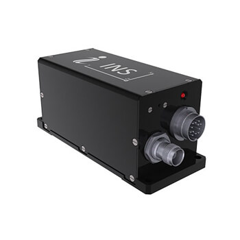
INS-P Professional 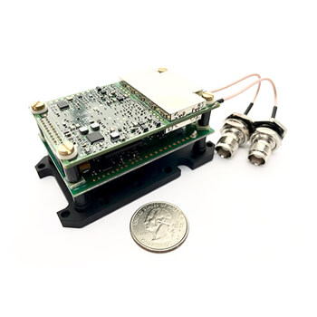
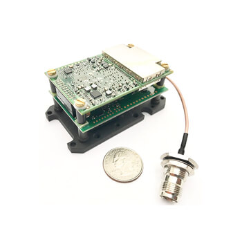
INS-D-OEM, INS-DL-OEM Dual Antenna 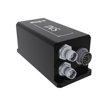
INS-D, INS-DL Dual Antenna
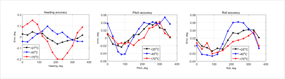
| Heading accuracy | 1 deg (SP) 0.03 deg (PPK) | 1 deg (SP) 0.03 deg (PPK) | 0.4 deg (SP) 0.03 deg (PPK) | 0.05 deg (SP) 0.03 deg (PPK) | 0.05 deg (SP) 0.03 deg (PPK) |
| Pitch & Roll accuracy | 0.1 deg (SP) 0.006 deg (PPK) | 0.1 deg (SP) 0.006 deg (PPK) | 0.1 deg (SP) 0.006 deg (PPK) | 0.1 deg (SP) 0.006 deg (PPK) | 0.1 deg (SP) 0.006 deg (PPK) |
| Size | 85x47x36 mm | 120x50x53 mm | 120x50x53 mm | 85x47x36 mm | 120x50x53 mm |
| Weight | 115 g | 220g | 280g | 115 g | 320 g |
| GNSS constellations & corrections | GPS L1/L2/L5; GLONASS L1/L2; BeiDou B1/B2/B3; GALILEO E1/E5; SBAS; DGPS; RTK |
| Position accuracy | 1.5 m (GPS L1); 1.2 m (GPS L1/L2); 0.6 m (SBAS); 0.4 m (DGPS); 0.01 m (RTK); 0.005 m (PPK) |
| GNSS and IMU raw data output | YES |
| Input data | Marine application: DVL (Doppler Velocity Log) Land application: Odometer, Wheel sensor, Encoder, DMI Aerial application: Wind sensor, Air Speed Sensor, Doppler shift from locator (for long-term GPS denied) |
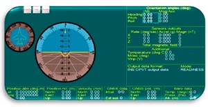
| Output data | Positions, Heading, Dual antenna Heading (D/DL), Pitch, Roll, Velocity, Accelerations, Angular rates, Barometric data, PPS, Direct AT_ITINS message with Position, Heading, Pitch & Roll to COBHAM AVIATOR UAV 200 |
GPS-Aided INS key performance
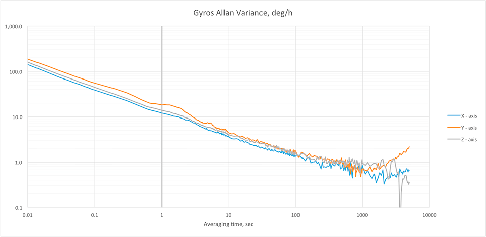
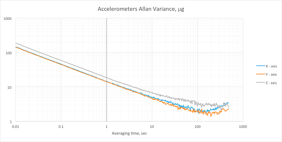
Gyroscopes & Accelerometers Bias in-run stability
Heading, Pitch & Roll accuracy
Descriptif
Le système de navigation inertielle assisté par GPS à une ou deux antennes d’Inertial Labs (INS) est une nouvelle génération de systèmes de navigation GPS L1 et L2, GLONASS, GALILEO et BEIDOU entièrement intégrés, qui déterminent la position, l’altitude, la vitesse , le tangage et l’orientation absolue (cap, tangage et roulis) de tout appareil sur lequel il est monté.
Les positions horizontale et verticale, la vélocité, le soulèvement et l’orientation sont déterminés avec une grande précision pour les applications statiques et dynamiques.
Les systèmes Inertial Labs INS utilisent un récepteur GNSS avancé, un baromètre, des magnétomètres Fluxgate de précision à 3 axes, des accéléromètres tactiques et des gyroscopes pour délivrer la position, la vitesse, le cap, le tangage et le roulis du dispositif à mesurer avec une grande précision dans toute sa plage de température opérationnelle.
L’INS contient un nouveau filtre de fusion de capteurs embarqués d’Inertial Labs, des algorithmes de navigation et de guidage à la pointe de la technologie et un logiciel d’étalonnage.
Caractéristiques et fonctionnalités
- State-of-the-art algorithms for different dynamic motions of Helicopters, UAV, UUV, UGV, AGV, ROV, Gimbals and Land Vehicles
- Single and Dual antenna GNSS receivers
- 1.5 meters L1 GPS & GLONASS Horizontal Position Accuracy
- 1.2 meters L1, L2 & GLONASS Horizontal Position Accuracy
- 60 cm SBAS Horizontal Position Accuracy
- 40 cm DGPS Horizontal Position Accuracy
- 0.5 cm Post Processing (PP) Horizontal Position Accuracy
- 1 cm + 1ppm RTK Horizontal Position Accuracy
- Up to 50 Hz GNSS positions data rate
- Up to 20 Hz GNSS measurements (raw) data rate
- 1 deg/hr gyroscopes Bias in-run stability
- 5 μg accelerometers Bias in-run stability
- 0.08 deg GNSS Heading and 0.4 deg Gyro-Stabilized Slaved Magnetic Heading accuracy (3 sigma)
- Highly accurate, reliable and temperature stable Fluxgate magnetometers (in-house technology)
- Advanced, extendable, embedded Kalman Filter based sensor fusion algorithms
- Full temperature calibration of all sensing elements
- Environmentally sealed (IP67)
- Compact design